This is a comment on our visit to Tewkesbury related to the Battle Trail and more importantly about information that adds weight to the likelihood that we had in fact skirted the location of the Lancastrian Battle formation when we had left lower Lode Lane to enter the path through the bushes and trees.
Although this content can be regarded as historical, political and perhaps a little spiritual, as Peter had kindly described my interests, I had already determined that this must be put in the Rhetorical blog of Polemical because the information available to us from historical writers is so at odds with each other, so different that it is difficult to establish a definitive version of events as far as location goes.
Having located a visual of the Battle trail, as walked, by looking at Google Earth and maps, the next stage was to search for contemporary reports from the period and also old maps.
While gathering this information together, it became apparent that there was no definitive location for the battle formations which were to stand facing each other in formation of three ‘battles’ for each side, but lots of variations with even one account being at 90 degrees to all other reports.
[Quote from the most recent document found]: ”Location and Description of the Battlefield
The battle took place in an area immediately south of Tewkesbury and bounded in the west by the Rivers Severn and Avon and in the east by the River Swilgate. Within that broad arena the initial deployment of the armies has been moved north or south depending upon the views of the historian and his interpretation of the available sources.” [unquote]
(Even within this statement the information isn’t absolutely correct but was inserted to illustrate the variance of historical opinion).
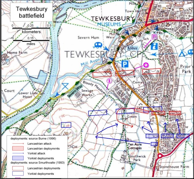
The breakthrough came quite early when I came across an ordinance survey map having two lots of locations depicted on it, and the location speculated by Smurthwait (1993) had put it right at the point where I had had the feelings of despair, terror and mourning and it could have been this fact that had provided a context for my experience and in turn seemed to provide a validation of that location. Also it makes sense of my immediate action of surveying the terrain left and right. However I felt it necessary to find a written report which would give a better insight into events.
Discovery was an interesting journey because relevant information does not all come in one go but over many searches, as the mood takes me, that is why it is over a period of time
Therefore it was only at a time closer to this Christmas that I finally decided to find the actual entrance point that Mathew and myself took because it certainly wasn’t the official signposted one with the widish gravel path which can be seen from the photographs posted at the location on Google Earth and maps.
I finally did find the location of our entrance by using street view and it is apparent that its location is a good distance before the official route and that we had in fact entered at the location of the extreme corner of the Lancastrians right flank, according to Smurthwaite. This also meant that we were approaching Bloody Meadow from the lane at an angle rather than at 90 degrees, which we could not see because of the vegetation that enclosed us and it is for this reason that we had what seemed to be a slightly downward path because we had been traversing along part of what can only be described as section of the earthwork or embankment that made up the site of Holm Castle.
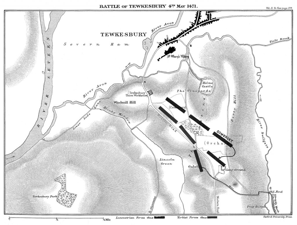
Holm castle is also a site that has been given differing locations and it was something which drew my attention to because one diagram depicted it right at the site close to Bloody Meadow and Lower Lode lane and because the typical construction of a castle is made in stone then this would exclude this area being used for the formation of the three Battles, the three block like groups of combatants. ( Much later after publishing this post I discovered the tourist map provided for the walk of the Battle Trail and it states that the A38 did not exist at the time of the Battle, and this explains why when I looked at the entrance to the Council offices, on Google Maps, the gradation of the road into it from the A38 is very shallow compared with the steep sides surrounding the edge of the rest of the Holm Castle site.)
The existence of Holm Castle then, was something that I had discovered at this late stage and it possibly explains the reason for the steep bank that I tried to run up. Also by taking a look at the terrain as much as is possible on Google Earth, it apparent that the site has a bank on three sides with the fourth side blending in naturally with the surrounding countryside, from what we can see from present day photographs.
”Here is a comment found today, 19th December, related to Holm Castle. This was sought because the castle is shown positioned on the Lancastrian staging post so would lend weight to the idea that the battle was fought away from this position but a report states that it was originally a Saxon construction of wood and that any subsequent more substantial rebuild was destroyed in the early 13th Century.
[Quote]”The castle was sited between the town and a large deer park, which was later the site of the battle of Tewkesbury (1471). Blyth argued the ruins of the castle were used in 1471 by the Lancastrian forces as a strongpoint, although this is contested. (see English Heritage Battlefield Report: Tewkesbury 1471. The original siting of the castle on a hill top probably had more to do with giving views to and from the park and town than any ‘defensive’ consideration and this castle, as is true of many castles, was a domestic high status house with pleasure pursuits as a principle rasion d’être. However, such a primary use does not exclude fortification and garrisoning in times of insecurity.”[unquote]
The English Heritage Battlefield Report: Tewksbury 1471 has been removed but the Battle of Barnet remains and this was also published in 1995 ”
Holm Castle is reported to have been Saxon in origin and constructed of wood and that any subsequent rebuild in more substantial material had been removed during the early 13th Century.
The feature about Saxon society is that rivers served as ‘their’ version of our present day motorways so the position of Holm Castle would not only provide for defense with a commanding view overlooking the river but also provide a location high enough to avoid flooding which is also the reason why the old town of Tewkesbury is located where it is, and as modern engineering improved, more usable land could be used for development, north east of the old town.
It is interesting to note also that where we made our entrance from Lower Lode Lane into the trail with compacted soil is also at a point directly opposite to where the River Avon curves in closest to the site and may in fact be remnants of an ancient path the Saxons used for access.
This path can be discerned from an aerial photograph taken in 1945 but this photograph is sightly displaced from all other satellite images. It also shows that the whole area across from the edge which aligns with the Bloody Meadow across to the Gloucester Road is open space, also with signs of what may be archaeological exploration. Later views of the site shows the development of Council Offices on the site and, at an even later date, along side it, what I had initially thought was a vegetable garden, but as it matured over the years, can be seen that they are actually trees. The formation pattern and area that these newly planted trees make is identical to that shown on a line drawn map from the 1850s , and which also shows trees lining the three sides which we see today. This was very interesting to me considering the general obfuscation of historical locations as already mentioned. This time however it was to replace trees that had been previously removed seemingly to return the site to it’s original state so that it appears, with reference to the 1850s map, that they had never been removed.
Also it has been mentioned that there has been no archaeological evidence of fighting having taken place in the vicinity of Margaret’s Camp, an area which has since been developed for housing.
Additionally information previously provided by an English Heritage Battle Report: Tewkesbury 1471 has also been removed while the Battle of Barnet which is set out in the identical format and has the same date of publication remains.
None of this would have been discovered had it not been for that spiritual experience that I had in a location I was unaware of but had it taken place at the official, signposted entrance into Bloody Meadow then I may have put it down to anticipation and expectation from within my self and quite likely that would have been the end of it with no curious investigation.
It is interesting that this emotion still effects me now whenever I think about it especially because of the fear and panic that reportedly raged within the Lancastrians but this was something that I could not understand because my allegiance is more towards Richard 111 or the Duke of Gloucester as he was then.
It was only a day or so ago that on awaking it dawned on me that there may be a connection ancestrally, realising that the Lancastrian supporters marched from Weymouth north to eventually stop at Bristol Castle to pick up provisions. We can’t really know if there is a connection or not but another experience that I had also came about when I had driven Mathew to a Building Society in order to transfer his account into his own name when he had become of age or rather during the following summer. When that process had been completed Mathew went on his way by bus and I made my way to the village car park to continue my journey to work which was nearby. When I arrived at the car I decided to visit the Church graveyard immediately next door to locate a possible ancestor which had been something that had kept coming to me to do for years but had never acted upon it. Of course I did not know of anyone except that as mentioned,for many years it kept coming to mind, beckoning me that I should take a look. So immediately into the Church grounds I looked down the far side to discover that it was just a single level office squeezed in, attached to the side of the main building. I then walked back to go down the right hand side of the Church building taking note of how weather worn the elongated slabs that had been set into the grass immediately between the path and the side wall. On the right hand side were a few small memorial stones dedicated to past vicars and beyond that in the great expanse of the grounds ran wows upon rows of headstones set at 90 degrees to the path and as I continued walking wondered to myself how I would ever find anybody related. However when I arrived at the far end of the Church building, I looked across to the path which ran parallel with the back of the church and my eyes were immediately set on a vertical headstone that was in silhouette and so made a beeline for it without looking at any of the others. To my great astonishment the inscription was for Elizabeth Hole who had been in service to one family for 27 years and must have been buried by that family. I did try to find out more information by visiting again and while there asked a grounds man who took me to the office to look up the records but it was simply a book recording the location of each headstone and nothing more. The headstone had been in silhouette because it had been leaning slightly forward, with the sun high in the sky, which in turn protected the inscription from weathering.
More to come,possibly, its in the bag already
Hello admin, i must say you have hi quality content here.
Your page should go viral. You need initial traffic boost only.
How to get it? Search for: make your content go viral
Wrastain’s tools
Thanks for your advice Greta. From my own point of view, I am not posting to become popular but the work is done on an altruistic basis although there was a time when some one mentioned on the radio that this activity is actually work. It had then crossed my mind to stop but this activity has now become an innate part of me and something which I enjoy on the ‘answering questions side’. Its the fun of the chase as it were.
It is the pursuit of answers to questions which may come intuitively, and to find that somebody else has already researched and presented the information in a very thorough way is much appreciated. This is also why I like to share.
My Facebook page had been primarily used for this purpose and for several years had only one follower but I did not mind. The most important thing is that people come if they want to, and I would rather that than to multiply followers artificially. That is the decision that I made.
Fortunately Peter Jones, my Facebook friend had appreciated the content of my writing and was inspired to make the effort to put in time and energy into creating this website. Peter is also keen to invite other contributors to this site.